Laya Gasa Trek is one of Bhutan’s most beautiful multi-day treks along the Tibetan border. From here, you will get to see some of the most fascinating and stunning Himalayan landscapes. Not only does this trek provide you with the opportunity to see diverse landscapes, but you’ll also get glimpses of peaceful farmlands, blue pine forests, and, on top of that, some breathtaking mountain views.
The whole trek is all about walking and immersing in the border regions of Tibet. The journey begins from Paro Valley and heads north, offering you a memorable trekking experience. In between, there are plenty of scenic beauty that captures your eyes from enticing farmlands to dense forests and alpine meadows.
This trekking trail takes you to lush green forests, including several flora and fauna such as rhododendrons, oak, blue pine, juniper, and many more. During this journey, you will get to see plenty of humongous peaks, such as Mount Jumolhari, Tsherim Gang, and Jichu Drake.
Additionally, you’ll cross high passes that are above 4500 meters. You’ll walk for around 5 to 7 hours a day, and the itinerary we’ve created takes care of potential risks, including altitude sickness.
One thing is for sure: this trek will test your endurance to some extent, at the same time rewards you with some of the finest experiences and memories in the Himalayas. This Laya Gasa trek is a must for travelers who are seeking to experience Bhutan’s pristine wilderness and cultural beauty with a complete off-beaten experience.
Highlights
Get to explore Laya, which is one of the popular cities of Bhutan.
Cross one of the highest passes of Bhutan, Shinche La Pass at 5,000 meters.
Gasa Hot Springs brings a different kind of relaxation and a moment of joy for travelers.
Get a chance to do a full sightseeing tour of Paro and a brief cultural experience.
Explore Thimphu, one of the modern cities of Bhutan.
Meet the Bhutanese people on the way and get to know their lifestyle and more.
Taste local Bhutanese cuisines and other exotic dishes.
Itinerary (18D, 17N)
Your journey to Bhutan begins with your arrival in the vibrant city of Paro. Paro is one of the historic towns of Bhutan, featuring plenty of sacred sites and buildings. It sits at an altitude of 2,200m/7,217ft.
This initial day allows for rest and preparation. It provides you with an opportunity to adjust to the local time zone. Use this day to make any final preparations for the Laya Gasa trek.
In the evening, you can take the time to explore the beauty of Paro and soak in the atmosphere. Experience the cultural richness of this city before starting the trekking adventure.
After having breakfast today, we will head to the Taktsang Monastery in Paro. The journey to the monastery takes place in a private vehicle. It takes about 20 to 30 minutes to reach the trailhead of the Taktsang Monastery.
From there, the hike to the Taktsang monastery begins taking you about 4 to 6 hours. The hike begins from the base and takes you to an altitude of 3,120m/10,236ft. For the ascent journey, it might take around 2 to 3 hours.
The ascent is a bit steep and requires a decent level of fitness. You also have the option to hire mules or horses from the base all the way to the mid-point. In the mid-point lies the cafeteria, where you can take some rest and continue the journey.
It’s best that you start the trek early morning so that the crowd becomes less. Keep in mind that the camera and phones are not allowed in the temple area.
On this day, you’ll drive from Paro to Drukgyal Dzong, which is a 30-minute ride. The ride will be scenic, giving you the sights of several settlements on the way. Drukgyal Dzong is a very popular fortress built in 1649 to glorify the victory over the Tibetan invaders.
This Buddhist monastery is located in the upper part of Paro city. Most importantly, it is listed as a UNESCO World Heritage site in Bhutan. After visiting this holy site, we’ll make way for trekking from the road end at Drukgyal Dzong.
We head to the north following the pathway of Pa Chhu (Paro River). In between the journey, you’ll get to see plenty of agricultural fields containing red rice, potatoes, and wheat. You’ll also get glimpses of farmhouse villages and thick forests.
After a couple of hours of walking, you’ll reach the military checkpoint, which is also called Gunitsawa. This is where all the trekking permits are checked. Shortly after the checkpoint, you will reach today’s destination, Shana.
Shana Zampa is more of a campsite; this place is an open meadow where tented camps are more commonly used. We will spend the night here by setting up the tented camps.
Today, we will be heading to Thangthangka from Shana. It is one of the long days where you have to walk for around 22 km. It is equally rewarding, too, with the views of farmlands and dense forests. On top of that, there are glorious mountain views in the background.
The trail follows the Pa Chhu, also called the Paro river. At first, you have to walk up a steep hill amidst the lush jungles. There, you’ll get to see blooming rhododendrons, bamboo, pine, etc.
Since it is one of the longest days of the trek, you have to do plenty of ups and downs with some stony paths in between. You’ll cross the iconic Shana bridge, which is pretty old. The following route also goes through the Tremo La Junction that goes all the way to Phari town of Tibet.
There lies Seyende Zam, which is a gorgeous chorten or stupa. You can also get glimpses of Mt. Jomolhari on a clear day.
Overnight at the tented camp in Thangthangka.
Today we’ll be reaching Jangothang, also called Jomolhari Base Camp. The trek begins with an uphill journey, taking you to open yak pastures. There will be nearly 500m of altitude gain on this day, from 3,575m to 4,044m.
We’ll again be following the pathway of the Paro Chhu River. You’ll even cross alpine meadows and huge yak herders of Tegethang. Shortly, near the Jangothang, the path opens up beautifully, allowing you to see the beautiful valleys and breathtaking views of Mount Jomolhari.
Jangothang means the ‘land of ruins,’ and you’ll see the remains of a fortress too. The following place sits just beneath some of the popular peaks of Bhutan, such as Mount Jomolhari and Jichu Drake.
The following part is moderate in terms of difficulty, and as we hit the altitude of 4000 m, caution and a steady approach need to be followed.
Overnight at a tented camp in Jangothang.
A rest/acclimatization day is usually taken the next day after trekking upto Jangothang. We’ve followed the same approach since the maximum altitude we’ve reached is beyond 4000m. Without proper acclimatization, it will be tough to continue the journey ahead.
This planned rest day in Jangothan is much needed for your body. This will ensure that your body adjusts well to the higher altitudes. You’ll be passing the mountain passes then, after.
Even on the rest day, you’ll get to see the backdrops of breathtaking Mt. Jomolhari and Jichu Drake. You can go for the short hikes, too, if you want to. There are plenty of hiking options, such as Twin Lakes, and even exploring the region of Mount Jichu Drake.
You can stroll around the land of ruins or simply enjoy the brisk moments in camp. Drink plenty of water on this day and get ready for the next day’s adventure.
The ascent journey will be more on this day of the Laya Gasa trek, nearly 800m. The highest that you will reach today is Nyile La Pass, which is around 4,870m/15,970 ft.
One of the best parts of trekking on this day is the chance to see amazing yak pastures, get to see blue sheep, and see the Himalayan backdrops in the background. These all make this trek a really memorable experience.
After the morning breakfast, you have to cross the bridge and climb following the caution to a ridge. From there, you will get the stunning views of peaks such as Mt. Jomolhari and Jichu Drake.
You’ll even bypass a rocky terrain near the Nyile La Pass. After making it to the highest point, the descent journey is pretty steep, too. It takes you to valleys filled with blooming rhododendrons shortly before reaching Lingshi.
Popular Lingshi Dzong is also there; grazing blue sheep are also one of the common sights that you can encounter during this trek. The camp will be set up near the Lingshi village.
Today’s trek will be mostly about descending to some extent to reach Chebisa. This is also the standard route of the Snowman trek. The journey begins from Lingshi taking the downhill path. In between you’ll catch plenty of small villages, dense forests.
There will also be high-ridge sections during the walk and you’ll see rhododendron flowers and fir. After reaching the Chebisa village you can stroll around the area, theer are plenty of water falls. Chances are high of spotting blue sheep too.
The challenging and tough climb unfolds today in the Laya Gasa trek. After the morning breakfast, we start one of the demanding segments or sections of the uphill journey. We head towards the Gogu La Pass in a high-altitude, rugged terrain.
Gogu La Pass is situated at an altitude of 4,440 meters, and the part of the ascent till this section is quite tough. After reaching the Gogu La Pass, the descent part is also long and stiff. The path isn’t easy; muddy at times, taking you to the Jholethang valley.
You’ll surpass thick forests of fir and birch. The trail continues as pass green valleys reaching the open yask pastures of Chachim. Right after some walking, you’ll reach the campsite at Shakya Pasang.
Even though the route passes through dramatic landscapes, the views of the shining Himalayas are a treat to the eyes. This day is a bit testing due to steep ascents and descents.
On this day of the Laya Gasa trek, we’ll be heading to the Robkuthang. The trek starts with an uphill climb until you reach the Jarela Pass. From there, you can witness the magical views of the surrounding mountains.
After spending some quality time in the Jarela Pass, we start the descent journey. You go through dense forests to reach Tsarigathang Valley. It is an open valley located at an high-altitude and in rough terrain.
Crossing several bridges and streams takes you to open fields and valleys. After that, you have to go through a short ascent climb to reach the campsite of Robkuthang.
The day’s trek is all about gorgeous mountain scenery and walking through some lesser-known valleys. Crossing Jarela Pass is another feat, as it sits at an altitude of over 4000m.
Today is one of the toughest days of this Laya Gasa trek. Robkuthang to Limithang is a tough journey due to high-altitude as from today onwards we reach 5000 metres. The highest point we reach today is 5,000 meters, which is achieved after crossing the high pass of Sinche La Pass.
Not only is the trail difficult because of high altitude, but also due to steep ascents and descents. The trek begins with an ascent climb and then involves passing huge glacial moraines.
The ascent climb is then followed by a descent journey taking you to the valley of Limithang. Limithang is also a tented campsite where we will spend the night. You should ensure proper caution as the trail is a bit rugged, and you will find some areas covered with snow, too.
Finally, today we will reach Laya from Limithang as part of the Laya Gasa trekking in Bhutan. The route passes through thick forests where you’ll find chirping birds and several wild animals.
In the backdrop lie the panoramic views of the Mt. Gangchey Ta peak. During the journey, you’ll get to see exquisite scenes of this peak. The trail towards the village of Laya is not a tough walk, giving you glimpses of the cultural richness and beauty of this region.
Starting from the campsite of Limithang, the journey descends to the village of Laya. In between moss-filled forests is one of the major sights, along with the shining scenery of Mt. Gangchey Ta. The steady descent from the Limithang for a couple of hours takes you to the valley where the Layap people live.
You’ll get to experience their unique culture, their way of life, and more info about them.
A rest day in Laya takes place today, giving you the ideal opportunity to rest and recover. It is also essential in terms of acclimatization, so that the body can adjust and adapt to such higher altitudes.
On this day, you can stroll around the cultural village of Laya and have meaningful conversations with the Layap people. The Layap people are known for wearing unique conical bamboo hats.
Visit the nearby surroundings, walk inside a stone-walled house to meet & greet with the locals. You can also taste chang, which is basically a barley alcohol that the locals love, and they may offer you.
Soak in the relaxing atmosphere and enjoy the pleasant views of the Gangchenta. Relax and let your body recover so that you can be fully prepared for the next day’s adventure.
With the start of the descent journey, we head even more downwards from Laya to Taktsimakhang. The downward journey from Laya goes through scenic landscapes following the pathway of the Mo Chhu (Mother River).
The more you walk downwards, the warmer the temperature gets as you pass several valleys and thick jungles. The trek will normally be of 2 to 3 hours, taking you to the place called Damji or the hot spring area. From there on, the driving part begins, by which you will reach the destination of Gasa Tsachu (hot springs).
From this day, the demanding sections of high-altitude trekking ends from here.
Today will be a relaxing day as we enter the latter half of the Laya Gas trek. You can totally rest and recover your body by immersing in the Gasa Hot Springs. The therapeutic waters will take away all your fatigue and stress.
It is also one of the ideal places to loosen the sore muscles that you may have developed during this lengthy & challenging Laya Gasa trek. The early morning soaking in the natural hot springs also freshens you up.
Then afterwards, we head up to the Punakha Valley in a private vehicle. The drive will be between 2 and 4 hours as the journey goes through several dense forests and valleys.
In between the journey, you will get to see stunning views of the valleys, farmlands, and different cultures. On top of that, you will also get glimpses of Gasa Dzong before you arrive at the historic city of Punakha.
Once reaching Punkha, you can walk in the nearby surroundings, visit the nearest attractions, and take a rest to be prepared for the sightseeing tour the next day.
Today will be an interesting day of the Laya Gasa trek as we will be doing a full day sightseeing of the Punakha city. Punakha is one of the most famous cities as well as the former capital of the country, Bhutan. And here lies plenty of major attractions featuring dzongs and spiritual sites.
Starting with Khamsum Yalley Namgyal Chorten, which is a very popular Buddha monument, you have to do a short hike to get there. From there, breathtaking views of the entire Punakha valley can be seen.
Another major attraction is Punakha Dzong, which is the second-largest dzong of Bhutan. It is located at the junction of the Pho Chhu and Mo Chhu rivers. There is a Punakha suspension bridge, too, which is the largest suspension bridge in Bhutan.
Chimi Lakhang is another popular temple, also known as the ‘fertility temple’. It is dedicated to the Divine Madman.
After the morning breakfast, we will start the journey from Punakha to Thimphu in a private vehicle. The drive unfolds with the drastic change in landscape, mainly from subtropical valleys to a more plain area. The scenic route includes dense forests, taking you to Dochula Pass and the serene Himalayan views in the background.
You’ll get to see 108 memorial chortens or stupas. Right after crossing the pass, there lies the Royal Botanical Park. It includes dense rhododendron forests, glimpses of Simtokha Dzong, a popular 17th-century fortress.
The road journey shifts from a warmer climate to cooler and forested highlands. Pine and rhododendron forests are widely seen. The road condition is quite good as it is mostly paved. Then, after spending some good quality time in Punakha time to head to Paro.
Driving to Paro is a different story, as it is a journey mainly through Himalayan landscapes. During this road journey, you will pass river valleys and several traditional valleys.
You’ll get to see plenty of monasteries and fortresses along with the breathtaking scenes of the Himalayas. The Thimphu to Paro drive is around 1 hour, which goes along the Paro River (Paro Chhu).
Finally, your Laya Gasa trek comes to an end. Departure day means the conclusion of your journey on the Laya Gasa trek. Depending on your flight schedule, we will arrange the flight drop-off services for you.
Depart from Bhutan with a sense of accomplishment. The moments and memories of the Himalayan landscapes and the beauty of this region will forever be etched in your heart. We hope to see you soon for another adventure with us!
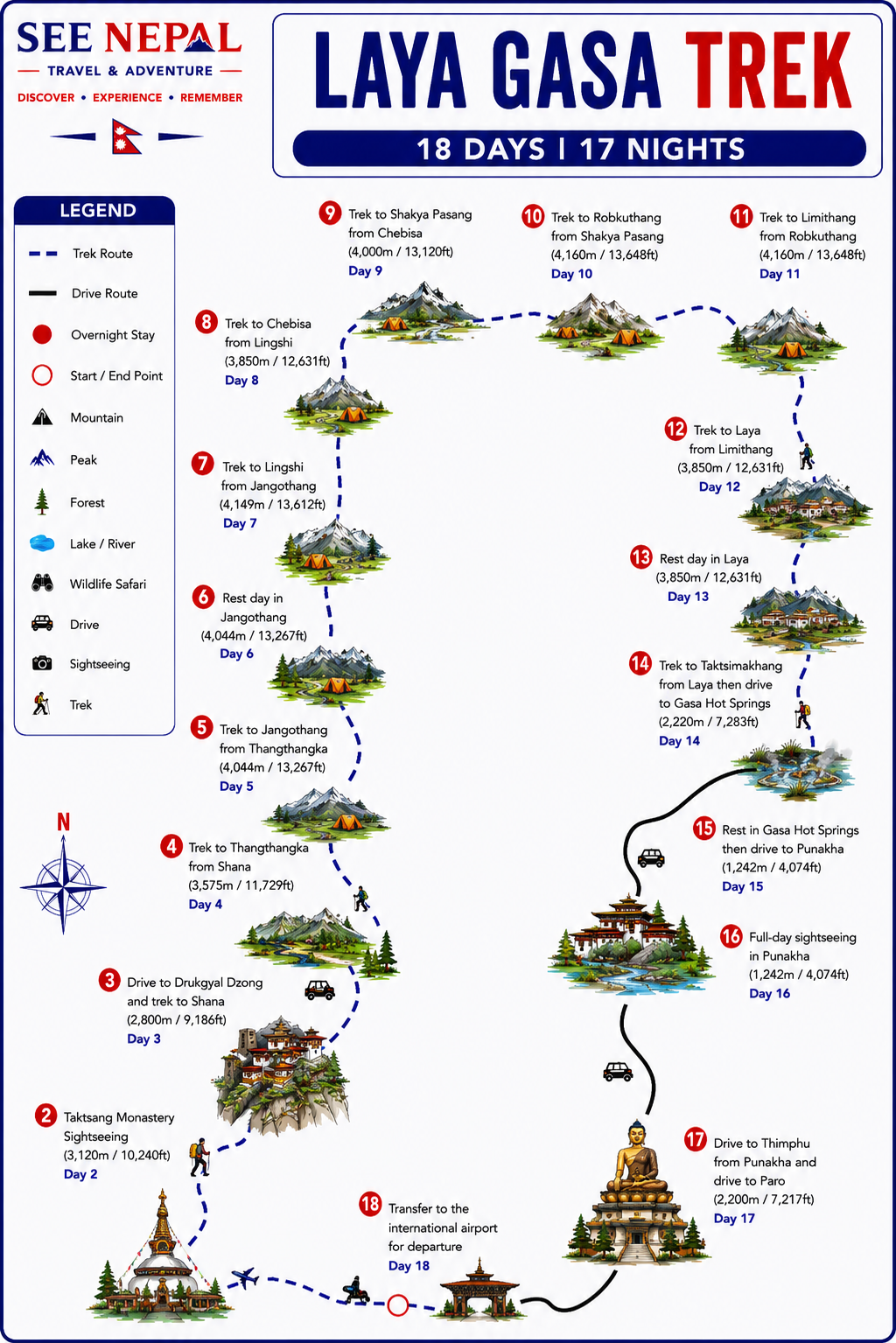
Trekking Map
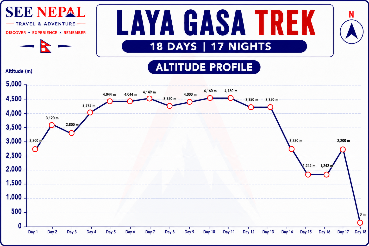
Altitude Profile
Inclusions & Exclusions
What's Included
Standard 3-star accommodation in main cities like Punakha, Paro (in twin-sharing rooms).
12-nights tented accommodation during the camping trek.
We provide two-man tents, dining tents, kitchen tents, toilet tents, shower tents, and many more.
Full-board meals throughout the stay, besides the arrival and departure days.
All airport transfers on a private vehicle.
Private transportation with a personal driver during the trekking period.
A licensed English-speaking, first aid-experienced Bhutanese tour guide.
1 porter for every two people with insurance and personal expenses covered.
Sightseeing tour in Punakha by private vehicle.
Kitchen helper/also a chef.
Bhutan visa.
As a souvenir, an Access Nepal duffel bag, a T-shirt, and Trekking maps.
Provides sleeping bags and down jackets if needed.
Adventure certificate.
Basic first-aid kits with an oximeter included.
All monument entry permits and fees.
Sustainable Development Fee of US$100 per person per night.
All government taxes and other charges.
What's Excluded
International flight to Paro.
Internet, travel insurance, charging electric devices, and personal expenses.
Meals during Day 1 & Day 18
Tips for guides and porters.
Extended stays and trips in Bhutan.
Equipment List
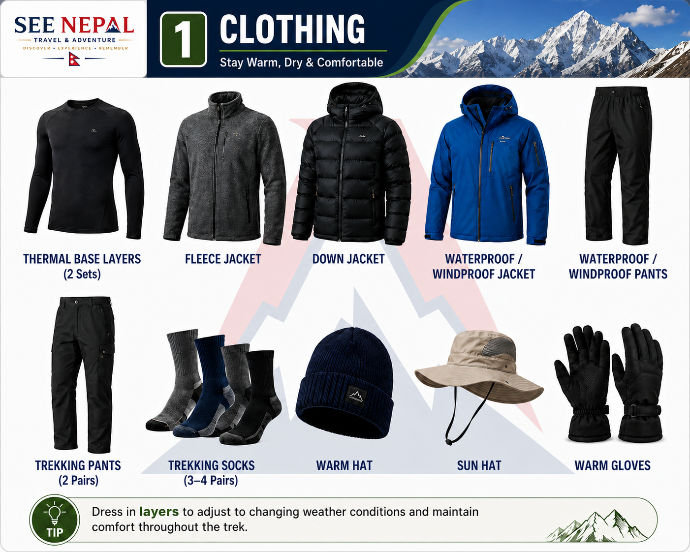
Clothing
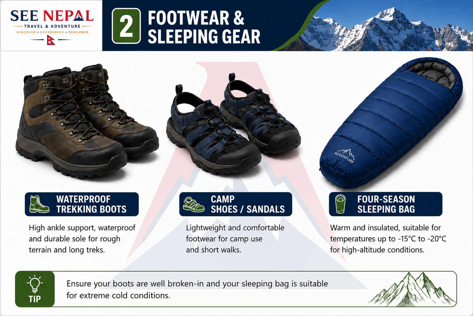
Footwear & Sleeping Gear
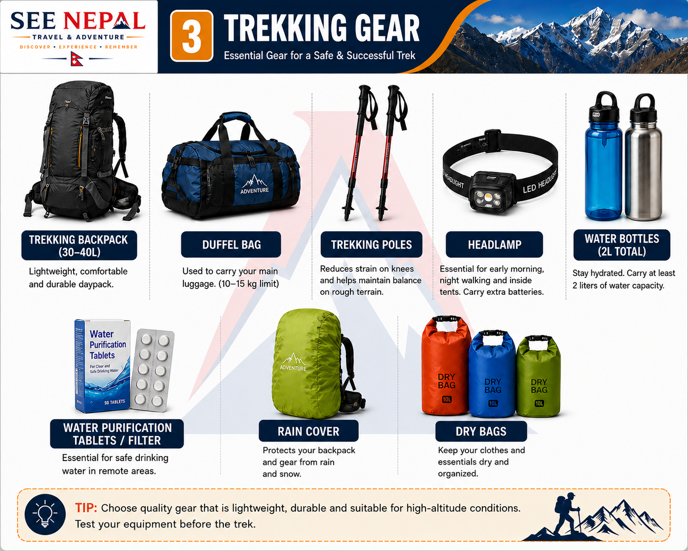
Trekking Gear
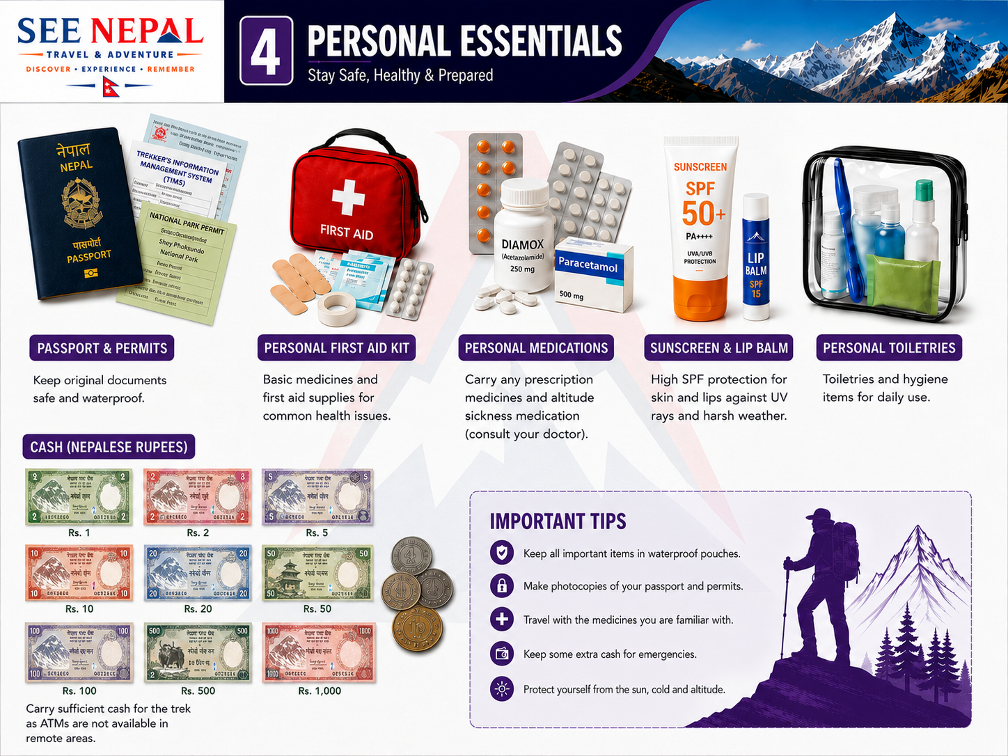
Personal Essentials
Electronics & Food
Frequently Asked Questions
The distance of this 18-day Laya Gasa trek is around 420 km. The trail lengths largely depend on the trekking days. The distance also fluctuates based on the itinerary and the starting point. Normally, it takes about 12 to 18 days to complete.
The trek is rated as a bit challenging, mainly because of the higher altitude. You will reach the highest point of Robkuthang with an altitude of 4160m. Not all days of trekking are difficult, as the itinerary also includes some days with short trekking hours.
The spring season (March to May) is pretty warm, not too hot. The temperatures range from around 12 to 17 degrees. At night, temperatures fall below, though.
Autumn is slightly different than the spring season in Bhutan. Daytime temperature can reach upto 12 to 17 degrees. Temperature falls gradually at night.
Visibility remains good at this time, and you can enjoy pristine mountain views.
The Laya Gasa trek can be done on spring and autumn seasons. March to May and late September to November are the ideal months. During this time, the weather remains open, visibility is good, and the views are majestic.
The Laya Gasa trek is graded as a challenging one, and one can only go for this trek after intense preparation. Yes, it is ideal for beginners too, but it isn’t an easy trek at all. We run this trek at an easy pace.
There is no specific permit required for this trek in Bhutan. You only need a Bhutanese tourist visa, passport, and one specific trekking permit. Access Nepal Tour and Trekking takes care of all these documents and permits.
Yes, the Sustainable Development Fee (SDF) is mandatory in Bhutan for travelers. You have to pay this daily fee to the Bhutanese government. It is included in the package cost.
For this Laya Gasa trek, trekking you need a valid passport and a Bhutan Visa at first. Other essential documents are flight tickets, passport photos, and travel insurance.
To book the Laya Gasa trek, go to the packages section. There is a package detail section on the right-hand side. Lies a ‘Book Now’ button which you have to click to begin the booking procedure.
For the Laya Gasa trek, it is highly advisable to get travel insurance, but not mandatory. You should make sure it covers medical expensies, injuries, trek cancellations, and more. Since you’re going over 4000m you should purchase travel insurance which can be handy.
Solo trekking is not allowed in Bhutan. You should mandatorily book the trek with the licensed tour operator. Any licensed tour operator from where you have booked the package handles all of these for you.
The checked baggage allowance is 30kg. This is for the flight to Paro. Please check your baggage allowance with other international flights, too.
The Laya Gasa trek is located on the northern side of Bhutan. It starts in Paro and takes you to the high-altitude near the Tibetan border. The path then descends to the Laya village.
Yes, the Laya Gasa trek is seen as Bhutan’s renowned trek. There are plenty of reasons behind it. During this trek, magical Himalayan views can be encountered, and provide you with the opportunity to experience authentic culture.
Yes, all the necessary permits and documents, such as a tourist visa, required for the trek are taken care of by us and included in the trekking package.
At the lower altitudes, especially on the cities of Punakha and Paro, you will find the three-start hotels. After reaching higher altitudes, you will have to stay in tented camps. The proper arrangement of camps and professionals is taken care of by us.
No, it isn’t safe to do the Gasa to Laya trek during the monsoon or winter season. During these months, you will face different kinds of challenges such as slippery trails, snowfall, freezing weather, etc.
The most common health risk is altitude sickness. Symptoms you need to look for are headaches, trouble falling asleep, vomiting, etc. It can go from normal to extremely severe conditions in a short time.
There is some chances of getting caught by altitude sickness. To get rid of it, you have to acclimatize and take enough rest, mainly. You have to ascend at a slow pace, allowing your body to acclimatize.
In the event of an emergency during the trek, the guide will take care of the situation. You should consult him. First aid is provided by the guide, but if the situation is intense, he will follow evacuation protocols instantly.